Wasn't the plane, was a thunderstorm we should never have jumped into but your right. 401. Didn't see the ground till 1500 feet. Why I always had a compass strapped to my chest. For civilian stuff I still put anything I can into mgrs cause it's what I like.
You are using an out of date browser. It may not display this or other websites correctly.
You should upgrade or use an alternative browser.
You should upgrade or use an alternative browser.
compass use
- Thread starter mongoose
- Start date
dfanonymous
Well-Known Member
- Joined
- Jul 16, 2016
- Messages
- 2,011
Yep, thunderstorm definitely would do it lol. Semper Gumby.Wasn't the plane, was a thunderstorm we should never have jumped into but your right. 401. Didn't see the ground till 1500 feet. Why I always had a compass strapped to my chest. For civilian stuff I still put anything I can into mgrs cause it's what I like.
D
Deleted member 48126
Guest
@dfanonymous to clarify my statement from my first post, terrain associate to get you to an area. Like you said back to the truck in the gravel parking lot. For pin point accuracy you're going to need a map, compass, and protractor (and super fine tip marker!). My longest movement using this method was 3 miles. I agree, no idea how I would do really long movements with this method. I think using a map and compass can get me into an area relatively well. I need to talk to my buddy on what he does without a GPS. He's done several challenging land nav courses without GPS.
I love all of todays tecknowledgey but I still use a compass as well
@dfanonymous to clarify my statement from my first post, terrain associate to get you to an area. Like you said back to the truck in the gravel parking lot. For pin point accuracy you're going to need a map, compass, and protractor (and super fine tip marker!). My longest movement using this method was 3 miles. I agree, no idea how I would do really long movements with this method. I think using a map and compass can get me into an area relatively well. I need to talk to my buddy on what he does without a GPS. He's done several challenging land nav courses without GPS.
A protractor is a key piece of kit for land Nav but depending on the type of area / terrain you're navigating, how youve planned your route, and if you've stayed engaged in your surroundings / location along the way, will dictate how often you need to use it. Land nav gets a bit more involved I've found when dealing with thick canopy jungles environments with lots of micro terrain, limited field of view ie areas where terrain association becomes more difficult.
Alot of it as @dfanonymous stated is route planning. Plan your route. Break it down into stages. Take note of key pieces of terrain / features and it's orientation to you during different stages of that route. Keeps you from having your head buried in your map all the time and enables you to be more in tune with what's going on around you.
With a proper map, compass, protractor, and skill, you can 100% land nav without a gps. People been doing it for along time but it's a heck of a helpful piece of kit to have at your disposal.
Last edited:
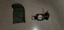
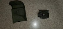
Believe it or not I learned to read maps and compass from my day, the Boy Scouts and then in the Corps. We didn't have GPS when I was in the Corps. Everything was done off a topographical map and compass. Well now I have the newest GPS loaded with several maps. However when I go into an area I still bring printed out Topo maps in plastic and my trusty compass that I got while a Marine 50 years ago. Can't trust electronics if the batteries go dead or the satellite fails. Even if you just have a Topo map, the stars, moss on trees you can get by from landmarks.
Attachments
Believe it or not I learned to read maps and compass from my day, the Boy Scouts and then in the Corps. We didn't have GPS when I was in the Corps. Everything was done off a topographical map and compass. Well now I have the newest GPS loaded with several maps. However when I go into an area I still bring printed out Topo maps in plastic and my trusty compass that I got while a Marine 50 years ago. Can't trust electronics if the batteries go dead or the satellite fails. Even if you just have a Topo map, the stars, moss on trees you can get by from landmarks.
Still got mine! Lol
I always carried a mechanical altimeter too.
Hugnot
Well-Known Member
For years I was sort of connected to compasses. Now my 2010 Honda has a compass, it can be corrected for deviations from the agonic line, if I cared to do so. I only look at it in parking lots to get shade advantages when the sun comes up. In the past I used a magnetic compass & barometric altimeter to locate topo features for map making. In the USN there was a magnetic compass on the vessels bridge complete with 2 iron balls (horizontal magnetic field correction) and iron rods (Flinder's bars, vertical magnetic field correction) and used with deviation charts. The compass was a backup for the directional gyro system.
Now, hand held GPS devices can be had. My GPS device does not work so good in deep wooded places.
Now, hand held GPS devices can be had. My GPS device does not work so good in deep wooded places.
AWESOM!!!View attachment 285640
Still got mine! Lol
X-2Believe it or not I learned to read maps and compass from my day, the Boy Scouts and then in the Corps. We didn't have GPS when I was in the Corps. Everything was done off a topographical map and compass. Well now I have the newest GPS loaded with several maps. However when I go into an area I still bring printed out Topo maps in plastic and my trusty compass that I got while a Marine 50 years ago. Can't trust electronics if the batteries go dead or the satellite fails. Even if you just have a Topo map, the stars, moss on trees you can get by from landmarks.
Hugnot
Well-Known Member
The front of the scoopy thing of the big dipper points to the North Star (Polaris) in event the compass is not there or the GPS is out.
Muddyboots
Well-Known Member
Haha! I carry 2 compasses! Always need a spare in case you lose one, or two. Sound familiar?