• If you are being asked to change your password, and unsure how to do it, follow these instructions. Click here

Calculating group size in excel

nksmfamjp

Well-Known Member
Joined
Jan 5, 2004
Messages
3,474
It seems like this should be easy, but all I can come up with is calculating the distance between each hole center and finding the largest one. That is a lot of math. Is there a better way to calculate shot group size from a list of xy coordinates from the target?

im doing it in excel because I want to combine shot groups from multiple targets.
 
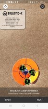
I use Ballistic-X
^ This
CAP4041178956471114078.jpg

Ballistic-X-Export-2023-02-18 22_17_58.073061.jpg
 
but how can I do it in excel with up to 50 shots?

My goal is to determine dispersion for large quantity groups shot by shooting many 3-10 shot groups.
 
If I was to try that, I would shoot 5 shot groups and in the spreadsheet show date, distance, caliber and rifle, speed, grain of bullet, grain of powder, temp, and MOA(group). It would be interesting to see how it reacts under different temps. After it's all said and done you still can come up with an average MOA accross different temps. If you're shooting bugholes you might need a SME Bullseye Sight In Range Camera. Using this will give you group size no matter how many shots.
 
If I was to try that, I would shoot 5 shot groups and in the spreadsheet show date, distance, caliber and rifle, speed, grain of bullet, grain of powder, temp, and MOA(group). It would be interesting to see how it reacts under different temps. After it's all said and done you still can come up with an average MOA accross different temps. If you're shooting bugholes you might need a SME Bullseye Sight In Range Camera. Using this will give you group size no matter how many shots.
WOW a lot of DATA!
I just have been doing it Old School all my life and it works for me.

Interested in the BALLISTIC X. So is that a program you purchase and then load your pictures into with your data and it calculates for you?

We have "Shot Marker" at our range, but never took all the time to set it up.
I do load development at our range in the back of our house. The when going to the PRS Range just shoot! (and hope to ring the steel)
Can't remember if I paid for it or not but it's a great app. Take a photo with your phone then open the app and follow directions. You can edit to show caliber and whatever else you want in it.
 

Attachments

  • Screenshot_20230317_213214.jpg
    Screenshot_20230317_213214.jpg
    366.9 KB · Views: 86
I have Ballistic-X. As far as I can tell, it is limited to 1 group per photo.….meaning I cannot combine 4 groups of 5 and see a composite group. That is all I'm doing.

for now I graph them and can see the combined groups. Then measure the two farthest apart.
 
Last edited:
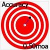
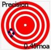
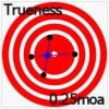
I'm trying to understand this. What does the 'composite' group represent? Is that an average? An average w/resp to what? Best? Worst? It almost sounds like you're looking for 'trueness'.
Accuracy.jpgprecision.jpgTrueness.jpg
If I can figure out what you want, I might be able to throw something together.
 
Manually measure the mean radius distances on each target and put them into excel to aggregate. You won't get a visual overlay of actual targets, but you'll get ATC group size and SD of horizontal and vertical dispersion from it, which is what really matters. If you really want a visual you'd have to do a second step of adjusting all the relative X/Y to the average center and plotting them on a cartesian plane. This is the manual version of what Ballistic-X is doing based on overlaying a digital grid on the picture you upload. It would be nice if they offered either 1) and export of the raw coordinates, or 2) an option to save coordinates into a profile and aggregate them for us.


Target example: (turns out I punched a random example of excellent accuracy with poor precision, group was almost perfectly centered on the aim point 🤣)
IMG_6929.jpg


Excel Example
excel 1.jpg


excel 2.jpg


If anyone is curious, the keystroke of CRTL+ ` (accent/tilde key, left of '1' and above 'Tab') flips Excel to showing cell contents instead of cell results, that's what is showing the formals in the second screen shot.
 
Last edited:
Top