Ballistic change between different places?

Brydawg512

Well-Known Member
Joined
Nov 16, 2018
Messages
442
Location
Idaho
Hello all,

I am looking to make some turret labels for my rifle, for quick dial hunting purposes. All shots would not exceed 600 yards, most likely never past 500.

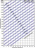
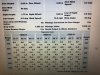
If I determine my DOPE say in 50 degree weather, during bear season where its 75-90 degrees and elk season where it's 40 or below, how significant will temperature changes affect POI at 500/600 yards? Also, elevation changes -- how much of an elevation difference to where POI will be affected significantly?

The rifle is a 300WM.

Thank you all. I know there will be some POI change, but curious to know if I can stick with the same turret across all of my seasons.
 
At 600yard you would see a difference of around 3 inches, but rember there are other contributing factors to consider like Pressure and Humidity.

You could zero at an average setting, but I always re-do/check my zero in actual feild conditions.

You could always have a couple of dope cards relating to the environment your in.
 
If you don't have a ballistic app then use JBM (online free calculator) and punch your numbers in and see for yourself. I still use it to print drop charts on occasion. I do something similar with turret labels, except make my own with blue scotch painters tape and a sharpie. You can change it to whatever your environmentals are. I will use this out to about the ranges you speak, and leave the turret markings (moa or mil) exposed to dial in longer ranges.
 
At 600yard you would see a difference of around 3 inches, but rember there are other contributing factors to consider like Pressure and Humidity.

You could zero at an average setting, but I always re-do/check my zero in actual feild conditions.

You could always have a couple of dope cards relating to the environment your in.

So, you are saying to gather an average humidity, temperature, pressure, and altitude for where I hunt for each season to create each drop card?
 
If you don't have a ballistic app then use JBM (online free calculator) and punch your numbers in and see for yourself. I still use it to print drop charts on occasion. I do something similar with turret labels, except make my own with blue scotch painters tape and a sharpie. You can change it to whatever your environmentals are. I will use this out to about the ranges you speak, and leave the turret markings (moa or mil) exposed to dial in longer ranges.

So, what about when pressure or humidity changes by the day? Snow/no snow, weather/no weather, etc... is there any way to do this without shooting my rifle for each specific environmental condition?
 
I can't help you with ballistic turrets. It's a headache I rather not have, but as said above use jbm. It will tell you what you need. I could literally tell you your drop, but as you seem to already know, it will change on a variety of circumstances.
Jbm you can print cards in multiple elevations and multiple weather. To help will not having 30 range cards, use density altitude and humidity at 50%. Humidity is negligible, especially at 500 yards. Use a gps when on the hunt to acquire you altitude and get a tool that can determine the temp, use a DA chart to figure out which DA dope card to use, find your range, index your dope and that's it. Make your shot.
 
500-600 yards your not going to see much difference for hunting. Just pick the average between the places you hunt and build a dope card for that.

Vortex use to have a nice function where you could pick the place you hunt on google and build a dope card for that. Not sure if it's still available, haven't used theirs in a year or 2.

My range is at 4000 ft and most of my hunting in around 7000ft and it's only about 1/4-1/2 MOA difference between the 2
 
I can't help you with ballistic turrets. It's a headache I rather not have, but as said above use jbm. It will tell you what you need. I could literally tell you your drop, but as you seem to already know, it will change on a variety of circumstances.
Jbm you can print cards in multiple elevations and multiple weather. To help will not having 30 range cards, use density altitude and humidity at 50%. Humidity is negligible, especially at 500 yards. Use a gps when on the hunt to acquire you altitude and get a tool that can determine the temp, use a DA chart to figure out which DA dope card to use, find your range, index your dope and that's it. Make your shot.

Ok, thank you. Now, when I use JBM, how do I input my "true" drop values so it can create the other "trued" drop cards with different elevations/temperatures? Also, I noticed on their website I have to input a bunch of variables like bullet length and what not -- if I'm using factory loads, how do I know this?

Understood about using a GPS for elevation and a tool for temp, but how do I determime my drop quickly? Do I have to carry several sets of drop cards with me that outline 3 different temperatures at 3 different elevations?
 
500-600 yards your not going to see much difference for hunting. Just pick the average between the places you hunt and build a dope card for that.

Vortex use to have a nice function where you could pick the place you hunt on google and build a dope card for that. Not sure if it's still available, haven't used theirs in a year or 2.

My range is at 4000 ft and most of my hunting in around 7000ft and it's only about 1/4-1/2 MOA difference between the 2

I hunt around the 5500-6000 mark, so you are saying I can build a card for, say, 5500 elevation, 50% humidity/density alt., and pick an "average" temp like 50 degrees and call it good?
 
So, what about when pressure or humidity changes by the day? Snow/no snow, weather/no weather, etc... is there any way to do this without shooting my rifle for each specific environmental condition?
If you play around with the ballistic calculator you will see exactly what your particular differences will be for your rifle/load, it will be different with different bullets at different velocities. Depending on the load, you will see out to some pretty decent ranges it takes a large change in environmentals to make a change worth worrying about. Check it out and just use it to the range you are comfortable with it to make your label. Like I said, leave the actual numbers on the turret exposed if possible and run with that when you are not comfortable with the amount of variance.
Added: I just punched in the numbers for my .300 Rum at sea level (home) and then where I hunt elk (8k +) and it was only a few inches out to 600. That's a big change, now do the same with temp and it may add a little more. Check it out for yourself.
 
I hunt around the 5500-6000 mark, so you are saying I can build a card for, say, 5500 elevation, 50% humidity/density alt., and pick an "average" temp like 50 degrees and call it good?

If that's what you think would work. I'm saying you can do the attached. It's more specific than that. And you can print as many versions that you need.
 

Attachments

  • 755AA4A4-A974-46AB-A2C4-AECA2B6B7422.jpeg
    755AA4A4-A974-46AB-A2C4-AECA2B6B7422.jpeg
    1.4 MB · Views: 175
  • 840A9DA4-1A61-4D3B-A168-B83ABC9DE053.jpeg
    840A9DA4-1A61-4D3B-A168-B83ABC9DE053.jpeg
    1.4 MB · Views: 181
  • AE1F9A17-12EE-4F7B-9B8E-C1A40BF9B3BF.jpeg
    AE1F9A17-12EE-4F7B-9B8E-C1A40BF9B3BF.jpeg
    6.4 MB · Views: 193
If you play around with the ballistic calculator you will see exactly what your particular differences will be for your rifle/load, it will be different with different bullets at different velocities. Depending on the load, you will see out to some pretty decent ranges it takes a large change in environmentals to make a change worth worrying about. Check it out and just use it to the range you are comfortable with it to make your label. Like I said, leave the actual numbers on the turret exposed if possible and run with that when you are not comfortable with the amount of variance.
Added: I just punched in the numbers for my .300 Rum at sea level (home) and then where I hunt elk (8k +) and it was only a few inches out to 600. That's a big change, now do the same with temp and it may add a little more. Check it out for yourself.

Ok, I think I'm having a difficult time grasping everything haha. I'm confused as to how I'm supposed to determine true drop when I'm out hunting, where weather, temperature, etc. are all so variable. Do I really need to sit there in the field with a calculator to compute it? I understand I can print charts ahead of time, but what if temperature, etc. Doesn't fit within the boundaries of the charts?
 
Warning! This thread is more than 5 years ago old.
It's likely that no further discussion is required, in which case we recommend starting a new thread. If however you feel your response is required you can still do so.
Top