Newbie tryin to research/plan a Wyo Goat hunt with alot of ?s

If you plan on going buy the chip. I have one and it's been extremely useful. Apply for an area where you have a good chance of drawing (and you want to hunt) and if you don't get a tag buy them online when the leftover licenses go on sale.
You have a better chance of drawing if you apply for a special tag.
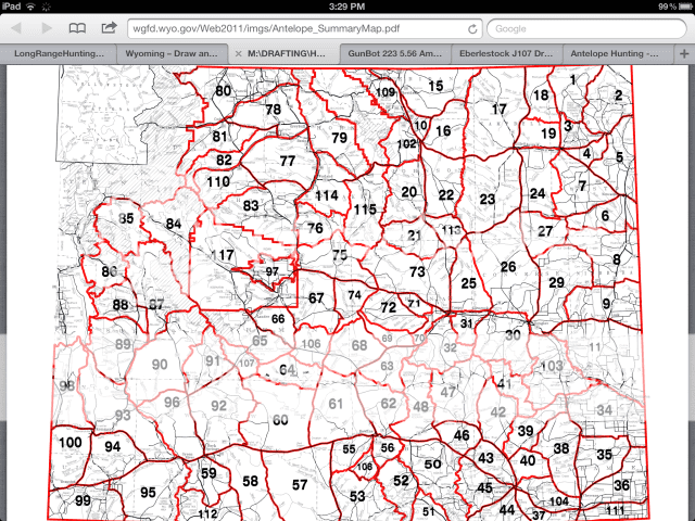
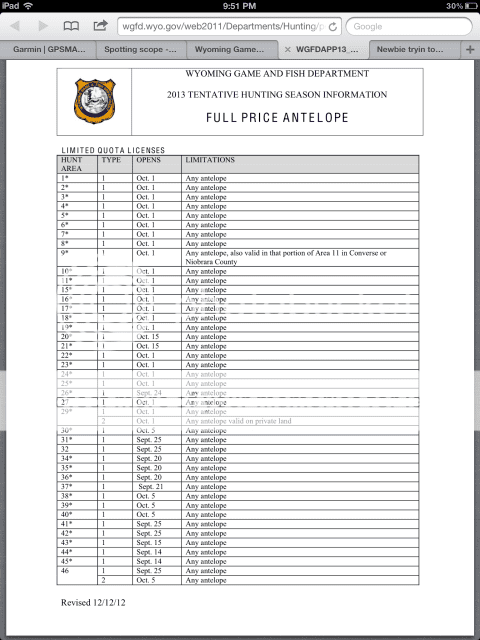
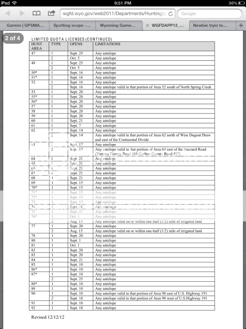
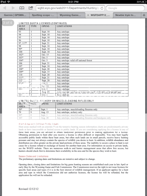
Locate the exact area you want to hunt before you apply and research it.
An alternative is to find a landowner in advance that will let you hunt for a reasonable tresspass fee in a mostly private area where it's easier to draw a tag. Sometimes they may let you camp also.
Go after opening weekend.
Talk to WY wildlife biologists for areas you want to hunt.
Good luck.
 
I appreciate all the help guys, I've been reading quite a bit on the Wyoming F&G site trying to figure out a game plan but im still baffled at all the different options for attempting to draw a tag.


But after looking at the draw odds all the ones that seem to have good % odds have an astrik next too them. So there's that many units that have very limited access? Is it worth the special draw to get a buck tag when you have 0 points?

1360293102_zpsa7e6c7b4.png


1360292811_zpsfa1281af.png


1360292895_zps4e2826f8.png


1360292934_zpsbc9b54fc.png
 
Thanks Canvsbk, What's everyones thoughts on the Hunters TrailHead site? https://hunterstrailhead.isecuresites.com/index.php?ID=1&XID=1:0:0:0:0

Is the info on there very helpful on how much public/BLM land is available to hunt on in each unit? And more help then the Wyoming F&G?

Another thing im trying to get a feel for is with the *astricts and people saying some units have very limitted access. Is that saying there's slim to no way to legally access the public land there or that you just really have to do some backpacking to get there.? Im not expoecting to be able to park the truck and walk a couple hundred yards and shoot a Antelope. Id rather hike quite a ways off the well beating path and atvs/autos and isolate myself from the majority of people that do the easier hunting. So if anyone can elaborate on this subject I'd appreciate it.

I really do appreciate your guys help.

Thanks Brett
 
The * means it's mostly private. There may be some public land. There is also "walk on" land. Go to the Wy G&F website to learn more about walk on land.
 
Check out the RED DESERT southwest corner. Between Rawlins and Rocksprings.
In the Norhteast there is a National Grassland Gillette area.
Remember lots of "public" use these, so the one who goes farthest off the beaten path will probobly see the most.
 
You are not really going to find very many units that have good public access without having some PPs. Even the Grasslands south of Gillette that were mentioned take one or two PPs to draw those units in the Regular Draw. You may find a few that you can draw without any PPs in the Special Draw, but you can't just look at a map that shows land ownership and decide to pick a unit because it has a lot of Public land. That is one reason a bunch of units have that asterisk after them showing difficult public access on the G&F website. Many times that land is landlocked by private property and if there isn't a public road that touches or goes through the public land it is not legal to get to it without permission of the rancher and normally they will want an access fee just like they own that land.
 
Thanks guys, yeah talked to Canvsbk and cleared up a lot of things. I have a set of 10x42 Leica Geovids and a NF 5-22, planning on picking up my first spotter this year too looking hard at the Vortex Razor HD angled.

So from what I gathered these sections all had 100% draw success for someone with 0 points in 2012

4 8 10 15
16 17 20 21
22 23 24 25
26 30 31 35
38 44 70 102

Now where is the best place online to check each section for the availability of public hunting land? Delorme map book? Then use that in conjunction with my GPS and chip?

Or could I buy the chip and use it on my computer ahead of time to research public areas?

Thanks for the tips

Brett

Some areas don't sell out for the draw and you can buy the left overs when ever you want but when the draw has a high rate of people that get drawn then usally there isn't alot of public land to hunt on.

Yes get the GPS chip. 2 years ago driving down the highway on the way to my hunting spot, I spotting a lone buck in a little postage stamp of state land surronded by private. The buck should have got a gps and he would of know he wasn't on private land like he thought.
 
38 is impossible to hunt public land unless you know a rancher. Cross it off your list if your going in blind.
 
Unless you want to pay a trespass fee you can cross off unit 70 too, there is some public access just very few animals. The last couple of years the numbers have been way down in that area, 69, 70 , 71 and 72 just don't have the numbers they did a few years ago.

Bob
 
102 is a big area. Most of it is tied up with private. There are a few acsess sites for some public land. Check your public land chip. If you looking for a big goat this might not be the best.
It also includes some NFS. There are some goats in the mountain on public land. It opens the 15 of Oct. Same day as deer and elk.
 
-Make sure your pants and shoes can withstand cactus and stickers. They are everywhere out there. Also get yourself a good pair of leather gloves for stalking in the cactii. Those stickers are not fun pulling out of your hands/knees.

My Sitka Mountain pants paid for themselves last fall in area 35. I also recommend carrying a plastic fork to pull the big round stickers out more easily.
 
Warning! This thread is more than 12 years ago old.
It's likely that no further discussion is required, in which case we recommend starting a new thread. If however you feel your response is required you can still do so.
Top