wildcat westerner
Well-Known Member
- Joined
- Nov 14, 2009
- Messages
- 680
Hello,
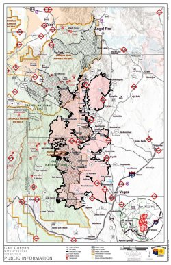
In northern New Mexico there was a huge Calf Canyon fire that destroyed hundreds of thousands of acres of forests and many homes. The burn scar is tremendous. Part of the scar extends into GMU 45 which for mobility impaired hunters had the highest success ratio for Mule deer in the state.
Four wheeling up to the snowline on a Mesa today the devastation was awesome.
Since I have been told that the rebound from this tragic fire will be uneven, good in some areas and mediocre in others, I am thinking that Google Earth may be a good way to cover such a huge area. In seekiing part of the area on Google Earth this afternoon, I realize these satellite photo's are simply not current at all. I am new to Onyx maps. How current would those images be?
So, it would be totally impossible to eyeball such a huge areas as to recovery. I still see this challenge as a good opportunity for a hunter to discover rebounding areas that return to their former state, or maybe even get better in terms of game recovery. I was in Washington after the Mt. St. Helens' eruption and the mountain's recovery in terms of succulent growth after the blast was miraculous, so the Roosevelt Elk herd migrated to that mountain for all the succulent growth.
I would be pleased to come up with the best method of tracking the recovery of this present devastation in the High Desert. Thank You,
WW