• If you are being asked to change your password, and unsure how to do it, follow these instructions. Click here

Google Earth Pro

SwampDonkeyBait

Well-Known Member
Joined
Jan 20, 2014
Messages
127
Location
Kalifornia
Hey all,

For all of you that use Google Earth for planning and scouting, I just wanted to give you a heads up that Google Earth Pro is now free. I just started using it and some of the features are great for planning (like private parcel locations, and numbers). One of the features I found useful is you are now able to draw your hiking route and google will give you the topographical profile. I set up a link below, or you can just type "Google Earth Pro" into your own search engine. Enjoy gun)

Google Earth Pro
 
Does it provide higher resolution images?

I believe the image is the same in either version, however Pro lets you print high resolution images. 1000 pixels vs 4800 pixels (Pro). This would be good for map making.

When I downloaded Pro, all of my saved locations and other data automatically transferred over, which was nice.
 
Thanks for the "heads up"! I'm VERY relieved to see that my saves places come over from the version I had on my desktop. I've wasted too many hours putting in places to have them deleted or not carry over.
 
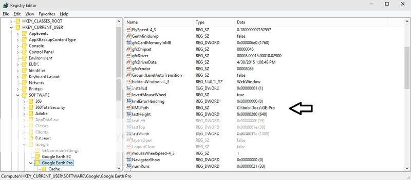
If you're computer literate, you can edit the registry to change the default location that GE uses to save it's "places" every time you close the app. That way, you'll never lose them even if you fail to "save places" within the app.


The upside to GE Pro is the ability to import .shp files as well as the ability to import geo referenced image files. My hunt area imagery in Pro is from June 2014.
 
The following is one of my favorite uses of GE, Pro version or not.

I capture on my gps a track while scouting or actually hunting. Then I transfer it to my computer, open it in one of Garmin's two free map programs. Then I choose "view in GE".

At this point I am able to view a 3d version of the route I took with the track showing as a yellow line.

Huge advantage for understanding the terrain.
 
I am fairly computer literate...but I've never used GE for anything...never really needed to, I do most of my hunting on ground that I've been stomping since I could walk...

But...I'm soon gonna be doing some hunting in other places, I hope...if all goes according to plan...that said, a little more detailed explanation of how all this works would be VERY nice.
 
Edit the registry key shown in the graphic to have GE save it's files in a folder you choose.

Before you edit the key, note the current location then copy the existing files to the new folder so GE will start with your existing places.

KML%20save%20location_zpsvpakaadh.jpg
 
Warning! This thread is more than 10 years ago old.
It's likely that no further discussion is required, in which case we recommend starting a new thread. If however you feel your response is required you can still do so.
Top