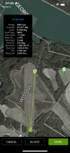
So I tested it three times out to 1000 yards this case it was 820 all three times it was between 20 and 60 yards off left or right actually to the right I did talk to my folks at Sig Who program it and they told me it's the lack of declination adjustment on BaseMap bass map is not replying back but the seat compass is working perfectly
You are using an out of date browser. It may not display this or other websites correctly.
You should upgrade or use an alternative browser.
You should upgrade or use an alternative browser.
Sig Kilo 8K and BaseMap
- Thread starter randycw
- Start date
stiff neck
Well-Known Member
- Joined
- Oct 27, 2008
- Messages
- 78
BaseMap seems to have stop responding to our inquiries.
I suspect BaseMap is "quiet quitting" ie going out of business. The app has been running slow and quirky for me, and has even frozen up to the point I had to restart my phone. It used to work great... My subscription is up in Dec, I may switch to OnX instead.
I suspect BaseMap is "quiet quitting" ie going out of business. The app has been running slow and quirky for me, and has even frozen up to the point I had to restart my phone. It used to work great... My subscription is up in Dec, I may switch to OnX instead.
That what I was seeing in other reviews.So I tested it three times out to 1000 yards this case it was 820 all three times it was between 20 and 60 yards off left or right actually to the right I did talk to my folks at Sig Who program it and they told me it's the lack of declination adjustment on BaseMap bass map is not replying back but the seat compass is working perfectly
stiff neck
Well-Known Member
- Joined
- Oct 27, 2008
- Messages
- 78
If was as simple as a problem of magnetic declination, wouldn't the error be the same for you each time you measured different targets instead of "between 20 and 60 yards off"?So I tested it three times out to 1000 yards this case it was 820 all three times it was between 20 and 60 yards off left or right actually to the right I did talk to my folks at Sig Who program it and they told me it's the lack of declination adjustment on BaseMap bass map is not replying back but the seat compass is working perfectly
If I recall correctly from my days as a Boy Scout, magnetic declination is only about 11 degrees where I am.
My question is, What are Sig and Base Map going to do about it?
Don't get me wrong, I like the range finder and probably would have purchased it even without the remote marker feature. The problem I have is that it was advertised and sold with that as being a feature of the unit. Sig and Base Map obviously had R&D time invested into putting this feature together. That in turn was added into the cost of the rangefinder and then passed on to the consumer. I believe as the customer we should get what was advertised and paid for or they should be fixing the problem. If the problem can't be fixed the consumer should have the right to return the product for a full refund, or Sig could offer a rebate or discount for not delivering on what they advertised and sold. Maybe if they get enough calls from people that have purchased them, or enough open complaints on the internet, they will feel obligated to fix the issue.
Don't get me wrong, I like the range finder and probably would have purchased it even without the remote marker feature. The problem I have is that it was advertised and sold with that as being a feature of the unit. Sig and Base Map obviously had R&D time invested into putting this feature together. That in turn was added into the cost of the rangefinder and then passed on to the consumer. I believe as the customer we should get what was advertised and paid for or they should be fixing the problem. If the problem can't be fixed the consumer should have the right to return the product for a full refund, or Sig could offer a rebate or discount for not delivering on what they advertised and sold. Maybe if they get enough calls from people that have purchased them, or enough open complaints on the internet, they will feel obligated to fix the issue.
Last edited:
From my conversation with Sig they have been trying to work with basemap but nothing but crickets from them?
Honestly I never would have used it anyway! I cant see a hunter calculating constant changing winds and have the time to remote marker on basemap to take the shot
Bottom line I use them 5 days a week (Kilo 10k) and so do my students, out to 1670 yards at this point I have found nothing the can equal it on performance and information given from it if there is I would love to try it?
Last edited:
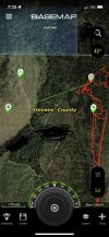
I'm not saying this would be something that would be used before taking a shot. It's after the shot or before a stalk is where I would be using it. Out here in the Pacific Northwest, we hunt in areas with reprod trees. Quite often you'll get an animal down in those trees from a shot across the canyon. You might even be able to see the elk or deer down from where you shot but once you go over to try and retrieve it it's like trying to find your way through a giant corn maze. It's amazing how what looks to be a 4' to 6' tree where you shot from is actually 10' to 12' tall when you get over there. I'm not saying that I'm expecting the remote marker to put me within a 5 yard radius of the ranged point, but 200 yards off isn't even in the ballpark for even trying to make it useful.Sig has been trying to work with basemap but nothing but crickets from them?
Honestly I never would have used it anyway! I cant see a hunter calculating constant changing winds and have the time to remote marker on basemap to take the shot
Bottom line I use them 5 days a week (Kilo 10k) and so do my students, out to 1670 yards at this point I have found nothing the can equal it on performance and information given from it if there is I would love to try it?
Bottom line is Sig advertised it as a selling point and that feature doesn't work. I haven't even heard of a single person that is using one say that it works on there unit. I would just like Sig and Base Map to address the issue, and either come up with a solution, or admit that maybe it's not going to work like they said and compensate the consumer who paid for the feature.
most I have seen it off is 60 yards
But I agree it would be a nice tool for marking an area the animal went down
I will bring up your point to them I talk them at least once every 2 weeks (the PM and Programmers) There is a few more features they learned in my class that are coming soon !
But I agree it would be a nice tool for marking an area the animal went down
I will bring up your point to them I talk them at least once every 2 weeks (the PM and Programmers) There is a few more features they learned in my class that are coming soon !
Well a 60 yard radius is still quite a ways off if a guy was wondering around in the thick stuff looking for his remote waypoint. The other thing I could see happening is that you watched a nice animal bed down. You range him with the remote waypoint and plan your stalk. You spend the next hour or so hiking around to get into a better position only to find out your waypoint was off and your looking in the wrong spot, or even worse you walk right into the animal. spooking him, thinking you have more distance to go than you actually had.most I have seen it off is 60 yards
But I agree it would be a nice tool for marking an area the animal went down
I will bring up your point to them I talk them at least once every 2 weeks (the PM and Programmers) There is a few more features they learned in my class that are coming soon !
Id be interested to hear what the people you talk to at Sig have to say about this. I would be disappointed if the results everyone is getting trying to use it is the same results that Sig and Base Map got before they put this out to the consumer.
pupdistress
Member
I just received my Vortex fury 5000ABS 10 x 42 yesterdayI'll be interested in what you find. My Kilo 2k is officially dead after 8 years so I'm looking. I like the features of the Kilo 8k over the Revic and The Vortex Fury 5000.
8k is the better of the 2 in my opinion
Vortex is slow. It will annoy you.
Yes that is correct it takes about 3 to 4 seconds for the solution to appear
stiff neck
Well-Known Member
- Joined
- Oct 27, 2008
- Messages
- 78
Magnetic declination in Eufaula AL = negative 4 degrees.most I have seen it off is 60 yards
But I agree it would be a nice tool for marking an area the animal went down
I will bring up your point to them I talk them at least once every 2 weeks (the PM and Programmers) There is a few more features they learned in my class that are coming soon !
Magnetic declination in Idaho = positive 13 degrees.
Your location determines how far off the angle is. Might be 60 yards off for you. Might be 180 yards off for me.
That's totally useless. Almost worse than a useless feature, is the silence from BaseMap.
Agree: The main use is marking downed animals as described above, and marking waypoints for a stalk or hike. That's how the feature is advertised. In my region, glassing across a drainage from one side to the other, steep hills with pockets of heavy oak forests and oceans of scrub oak, once you get in there it's hard to find a target.