Measuring target distance with GPS

I am setting up a range for up to 4,000 yards. I want to use a simple GPS for measurements. Not sure which ones will work. BUT....I DON'T NEED MAPS!! All I need is the ability to mark both ends of the path and have it calculate the distance. Assuming level ground. Even without the calculator I could use pencil and paper to calculate it if the unit would give me the GPS positions. It seems that most small handheld units are geared to using maps and land marks, not just raw GPS.

But there may be some out of the box solutions as well.
1) is there a program for tracking that will use my phone to find a tagged object and give me the distance to that object?
2) Since my phone does have GPS information that is accessible to the police, how can I access that information?
3) maybe time the bullet from firing line to target? That would be hard without very accurate instruments.
Any other ways other than a 3 mile tape measure?
 
Different way to skin the cat=old school

Wild.jpeg.jpg


What took a lot of figuring, thought, gadgets and art 30 years ago now can be done with with a cell phone and a few programs.
All in the spirit of a mans gotta know his limitations or lack there of.
Have fun its a trip!
 
Download the google earth free app.
Click the ruler, set your end points.
It really is that simple.
 

Attachments

  • CEABE626-F633-44E8-9DDC-034A6A0795DB.jpeg
    CEABE626-F633-44E8-9DDC-034A6A0795DB.jpeg
    78.6 KB · Views: 40
  • 02F27C5F-E2FC-4740-B8DF-1931BF561468.jpeg
    02F27C5F-E2FC-4740-B8DF-1931BF561468.jpeg
    380.5 KB · Views: 44
  • 038A59C8-2939-4BBF-AE80-94E97E2C83F3.png
    038A59C8-2939-4BBF-AE80-94E97E2C83F3.png
    1.2 MB · Views: 51
You could also look for a vintage military rangefinder as used by all the various forces in both WW1 and WW2.
Ones in good clean condition can often be found on EBay for about the price of the average new lazer rangefinder.
The Swiss made WILD that i still use was made in the early 70s and will range out to 10.000 meters.
Very accuratly as well, although i haven actually tried ranging nearly that far with mine.
Sun rain or snow makes no difference, if you can see the target you will get the range.
They weigh about 15#.
The Barr&Stroud model which i also owned and used for many years ranges out to 20.000, and some of those including the one i had measure in yards.
4000 yards would be a cake walk for one of those units.
Check with Cheaper Than Dirt, not long ago i heard they had some as new Wilds for about $400.
a
Good luck. I personally prefer to stalk to within normal range. It called a challenge.
 
I would get a large piece of cardboard for a rangefinder target and then do the distance in increments. You can use cosine distances to compensate for up and down if you have to walk or use the ATV. You can use onX or any GPS to keep a straight line. Two methods would be good.
 
I am setting up a range for up to 4,000 yards. I want to use a simple GPS for measurements. Not sure which ones will work. BUT....I DON'T NEED MAPS!! All I need is the ability to mark both ends of the path and have it calculate the distance. Assuming level ground. Even without the calculator I could use pencil and paper to calculate it if the unit would give me the GPS positions. It seems that most small handheld units are geared to using maps and land marks, not just raw GPS.

But there may be some out of the box solutions as well.
1) is there a program for tracking that will use my phone to find a tagged object and give me the distance to that object?
2) Since my phone does have GPS information that is accessible to the police, how can I access that information?
3) maybe time the bullet from firing line to target? That would be hard without very accurate instruments.
Any other ways other than a 3 mile tape measure?
Use gps and a laser range finder together.
 
If you have any elevation changes between the points, the typical gps map functions will give you the ground distance. This will not be an accurate distance for shooting. You would need to know the angle of the slopes and height plus using cosine to get the exact distance.

For example, shooting at a target that is 2000yds out, when measured on foot, but there is a hill in between. The distance accounts for you walking up and down the hill. If the hill wasn't in the equation it would be 2000yds. However, the distance up and down the hillside throws off the true line of site measurement of 1800yds
 
If you have an iPhone (I don't know about androids), I'd think about the free app from Under Armour "Map My Walk." Or a range finder for $ 😊
 
I am setting up a range for up to 4,000 yards. I want to use a simple GPS for measurements. Not sure which ones will work. BUT....I DON'T NEED MAPS!! All I need is the ability to mark both ends of the path and have it calculate the distance. Assuming level ground. Even without the calculator I could use pencil and paper to calculate it if the unit would give me the GPS positions. It seems that most small handheld units are geared to using maps and land marks, not just raw GPS.

But there may be some out of the box solutions as well.
1) is there a program for tracking that will use my phone to find a tagged object and give me the distance to that object?
2) Since my phone does have GPS information that is accessible to the police, how can I access that information?
3) maybe time the bullet from firing line to target? That would be hard without very accurate instruments.
Any other ways other than a 3 mile tape measure?
Response:
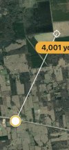
1) Google maps will do that. Drop a pin at one location, go to another and you can get the distance to the pin.

2) Direct access to GPS information on your phone is difficult at best, and not very useful. Physical access yo your phone might be required.

The apps you use (such as Google maps) send the location derived from GPS data it to Google (or whomever), Google generates maps and other information which is returned to your phone via the internet. The data going to/from you and your service provider and the application provider is much more useful & accessible to police (and others).

If you download local maps of an area to your phone you can probably do what you want offline but I'm not sure if Maps sends location data to Google after you reconnect. Data that police (and others) might access is what you see on your application history.

Turn on the option for "precision location services" on your phone for better accuracy. This requires internet access and access to at least 3 cell towers from the location of interest.

3} A surveyor with a transit can probably do better but it could be very costly if reference markers are far away, which is likely since you're probably in an isolated area.

A surveyor with better GPS equipment (i.e. dual channel with more advanced algorithms) could get you down to a few centimeters or even less if you leave the equipment sitting at a position for several days. This equipment is expensive, you probably don't want to buy it.


Other thoughts:

If you are interested in seeing the raw GPS data as sent from satellites, I'm not sure of any commercial app to display it. The raw data is useless to most people, only developers working on GPS-based equipment or software would really dig into it & the reams of data needed to understand it. Most companies that want to include GPS on a new product would buy a design from somebody else because of the difficulty & cost involved.

Basic GPS like on your phone isn't that accurate (4.9 meters/16 feet radius horizontally and 1.7 times that vertically about +/- 8.3 meters/27.3 feet). That is about 0.27% horizontal error at each location, 0.54% total.

Dual-channel GPS (which is what the military and some commercial users use), can get you to a few centimeters or even millimeters if you leave the equipment in place for days. It is expensive and bulky. You might find a surveyor that has it.

Your mobile phone usually has an option for higher accuracy location services (look for precision, high precision, high accuracy location services). This doesn't use GPS, the implementation needs to hit several cell towers, the cell tower equipment measures the signal strength at each tower, then an algorithm uses this along with the tower locations to triangulate your position, the position is sent to your phone and/or application via the internet. There are several refinements that can improve accuracy further. The accuracy of this depends on your mobile service provider's specific implementation and your location. Towers near a remote location are probably going to be far away, which would probably result in greater error than if you were close to the towers.
 
I am setting up a range for up to 4,000 yards. I want to use a simple GPS for measurements. Not sure which ones will work. BUT....I DON'T NEED MAPS!! All I need is the ability to mark both ends of the path and have it calculate the distance. Assuming level ground. Even without the calculator I could use pencil and paper to calculate it if the unit would give me the GPS positions. It seems that most small handheld units are geared to using maps and land marks, not just raw GPS.

But there may be some out of the box solutions as well.
1) is there a program for tracking that will use my phone to find a tagged object and give me the distance to that object?
2) Since my phone does have GPS information that is accessible to the police, how can I access that information?
3) maybe time the bullet from firing line to target? That would be hard without very accurate instruments.
Any other ways other than a 3 mile tape measure?
GPS Is only 3 square feet accurate.
 
I downloaded Measure Map and it looks like it will work. Just measured the distance from my house to the yacht club as 10.48 miles. Easy peasy and free.
 
I am setting up a range for up to 4,000 yards. I want to use a simple GPS for measurements. Not sure which ones will work. BUT....I DON'T NEED MAPS!! All I need is the ability to mark both ends of the path and have it calculate the distance. Assuming level ground. Even without the calculator I could use pencil and paper to calculate it if the unit would give me the GPS positions. It seems that most small handheld units are geared to using maps and land marks, not just raw GPS.

But there may be some out of the box solutions as well.
1) is there a program for tracking that will use my phone to find a tagged object and give me the distance to that object?
2) Since my phone does have GPS information that is accessible to the police, how can I access that information?
3) maybe time the bullet from firing line to target? That would be hard without very accurate instruments.
Any other ways other than a 3 mile tape measure?
If your using Ballistic Arc software For your shooting it's That's simple and you probably know how to use it. Go to mode in bottomed middle of the screen, then click map ( and pull the map on your range) you can set this up for multiple shot length as well.

geoballistic is another piece of software that works fairly well but it cost 15$ or so
 
I am setting up a range for up to 4,000 yards. I want to use a simple GPS for measurements. Not sure which ones will work. BUT....I DON'T NEED MAPS!! All I need is the ability to mark both ends of the path and have it calculate the distance. Assuming level ground. Even without the calculator I could use pencil and paper to calculate it if the unit would give me the GPS positions. It seems that most small handheld units are geared to using maps and land marks, not just raw GPS.

But there may be some out of the box solutions as well.
1) is there a program for tracking that will use my phone to find a tagged object and give me the distance to that object?
2) Since my phone does have GPS information that is accessible to the police, how can I access that information?
3) maybe time the bullet from firing line to target? That would be hard without very accurate instruments.
Any other ways other than a 3 mile tape measure?
Set up your GPS to use UTM's or Universal Transverse Mercator. That measures in meters, Easting is meters East of an arbitrary line or zone boundary. The Northing is meters North of the equator. Then use the Pythagorean theorem to calculate the distance or length of the hypotenus.
13T
XXX
284738​
from here
From Point A to Point B is:​
-221​
221​
4838390​
MetersYardsMilesFeet
-246​
246​
330.69361.640.211084.93
YYY
284959​
to here
4838636​
These numbers above are Easting and Northing from the GPS
 

Recent Posts

Top