Where I hunt I can go from 400m ASL to 2500m ASL in a trip, so I am going to make a chart with sighting corrections for different pressure conditions.
I understand that if I set the reference altitude on my Kestrel 2500 to 0m it will give me raw pressure data, or station pressure.
Looking in Exbal, it has fields for 'pressure @ sea level' and 'pressure @ altitude'
Why are there 2 fields?
In case it's not clear, what I want is something that looks like this:
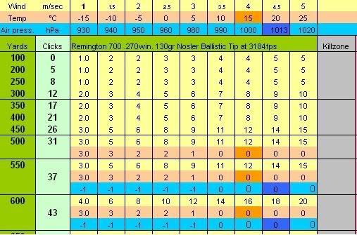
So that I can look at my Kestrel, see the station pressure, look at the chart and make the appropriate adjustment... ditto for temperature.
Help?
I understand that if I set the reference altitude on my Kestrel 2500 to 0m it will give me raw pressure data, or station pressure.
Looking in Exbal, it has fields for 'pressure @ sea level' and 'pressure @ altitude'
Why are there 2 fields?
In case it's not clear, what I want is something that looks like this:
So that I can look at my Kestrel, see the station pressure, look at the chart and make the appropriate adjustment... ditto for temperature.
Help?
