How to Get There from Here
By Nate Simmons
Integrating today's mapping technology to better your hunt
©Copyright Elk Hunter Magazine
Two of the most overlooked and underrated pieces of equipment these days are maps and GPS devices. No doubt, there are far more exciting pieces of hunting equipment out there that are far more fun to use and play with. However, when it comes to aiding to the success of any hunt (public land especially), a good map/GPS combo is as important as your weapon or optics.
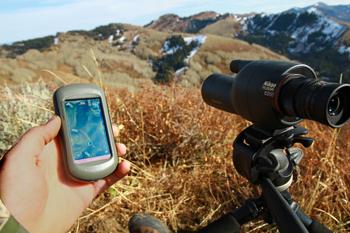
While having just a map or GPS alone is better than having neither, the combination of both is critical to get the most out of your hunt, especially when hunting new areas. I actually still pack both even when hunting familiar terrain, for two reasons: 1) It can be hard to find your way back to camp or the truck in the dark without a GPS, and 2) I like having a printed map to make notes on what I experience, so I can keep adding to my log and help notice patterns and subtle trends.
The reason I feel it's important to have both is that you can't get a good feel for the lay of the land (topography wise) by viewing a topo map on a GPS screen; there just isn't enough screen real estate to see much area in detail, and that's important to be able to see how drainages tie into one another and spot possible travel routes, glassing points, etc. And while a printed map has its strengths, it can't tell you precisely where you're standing and how to make it back to a particular location like a GPS can.
Another important aspect to consider is land ownership info. This can be displayed nicely on both printed maps and in GPS mapping software. There are some great custom map-making companies out there catering to hunters by printing maps with multiple data overlays on them, such as game management unit boundaries, BLM, state, Forest Service and private land boundaries on them. The great thing about these maps vs. a standard Forest Service or BLM map is that you have the ability to only print the area you want to see, whether it's your entire unit or units or a section of your hunt unit at whatever scale you prefer. Typically, a BLM or Forest Service map doesn't offer much detail in topography as they scale back to show large amounts of terrain. That makes it hard to see things like benches, subtle saddles, etc., with the scale of these maps in the range of 1:100,000 and greater. That translates to about one inch representing roughly 1.6 miles or more, where a good detailed topo map will be at a scale of 1:24,000 (referred to as 7.5-minute series), with one inch representing roughly .4 miles, allowing you to see far more detail in the topography. The problem with custom maps is that it can get expensive in a hurry.
My Mapping System
What's the solution? Well, there isn't a perfect one, but here is the system I've been using on my hunts, as it gives me all the data I could possibly need. For having access to data on land ownership status, I use two things: 1) a BLM or Forest Service map. This allows me to see large amounts of data at once and see the big picture on where the public lands lay and how to access most of them. I typically don't pack this one with me all the time, but just keep it in the truck or at camp in case I need it; and 2) a GPS, along with third-party software loaded onto it that shows all the land ownership status data, game management unit boundaries, and in some cases, the names of the private landowners. This is very powerful info, as it can do what no printed map can - show you where you are located in relation to a property line. This is a huge confidence-builder, as property lines are not always marked accurately, or at all.
HuntingGPSmaps Third-Party Software
The third party software I've been using is called "HuntingGPSmaps", made by Montana Mapping & GPS, LLC (available at the Long Range Hunting Store). This company has a good understanding of what hunters want and need, and how to make the product easy to use effectively. This product is sold several ways.
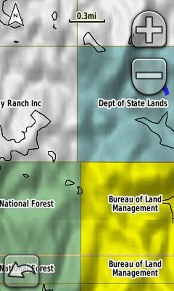
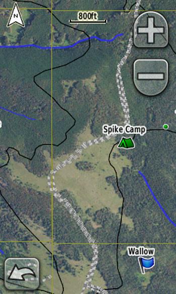
MontanaGPSmaps Software on Garmin GPS: Here you can clearly see on the GPS screen what the land ownership status is - and even the private landowner's name - by using the MontanaGPSmaps software. The best part is that the GPS will show you your exact location in relation to a property line.
Option 1 is to buy a mini SD card that can be inserted into compatible Garmin GPS units. You can see a list of compatible GPS models on their website, as well as a list of retailers.
Option 2 is to download the software from their website onto your home computer. You can then transfer it onto your GPS.
The map software is sold on a state-by-state basis and costs about $100 per state for the SD card and $130 per state for the downloadable versions. While both of these versions work the same way on your GPS, they do have their pros and cons. The mini SD card is easier to get going, as all you do is insert the card and go. The download is more time-consuming and takes a little time getting it transferred from your computer to the GPS, but the benefit is that you can view the map on your computer as well, which is nice for scouting and seeing a larger area than you can on a small GPS screen.

While this software is not inexpensive, it's still a value when compared to the cost and time of getting even small areas of a state printed on a custom map with the land-ownership layers, not to mention you can't pay a paper map to tell you exactly where you're standing in relation to a property line (priceless info).
USGS Quads
So this takes care of everything on the land ownership status front, but having the BLM or Forest map along with the GPS software still doesn't offer much for detailed topography. Even though the HuntingGPSmaps software offers great detail at a scale of 1:24,000, which is what I want, the problem is that when you are zoomed in, the GPS screen is too small to see much country at once.
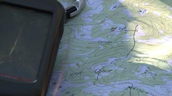
Because of this, I still need another map. For this, I just need a basic map at a scale of 1:24,000 that has contour lines and shows where the timber is located, so I can see the lay of the land easily. There are several ways to track these maps down, but a USGS 7.5-minute quad is hard to beat for the price. They cost $8 per map and each map covers roughly 60 square miles on a 16"x22" sheet of paper. The drawbacks are that these don't offer shaded relief, which makes them a little tougher to read the contours, and you can't have the USGS center a map on a particular location (they are all fixed areas).
This can be a pain if your hunting area lies on the edge of two maps and you have to piece two maps together to see your area. You can either buy these online at www.usgs.gov, or track them down fairly easily by asking around at local sporting good stores.
National Geographic Topo Series
Another way to go is with the National Geographic Topo State Series software. It allows you to print your own maps at home at the scale you select and the exact area you select, but unless you have a giant plotter, you will have to tape papers together to see much at once. The other downside is the price; it's $50 per state, so it depends on how many places you hunt each year and how many maps you need in order to see if the price is worth it. These maps, like the USGS qu
BirdsEye Satellite Imagery
Seeing vegetated areas is key for seeking out potential bedding areas and travel routes, but I take it a step further by downloading a satellite image onto my Garmin GPS. I've been using Google Earth to "scout" from home and see what my hunting area looks like from the sky, but it's not always easy to remember it perfectly. So, having an area's satellite image on your GPS can be a very useful tool - especially when hunting elk - to help locate good-looking meadows, timber pockets, etc.
BirdsEye Satellite Imagery: This is a screen shot of the BirdsEye Satellite Imagery from a Garmin GPS; it's not hard to see the value in this, as spotting the best meadows is even easier than reading a topo map.
I was able to get this onto my GPS through Garmin's website for $30 (annual subscription with unlimited downloads). If you know all the areas you will hunt in the next few years, you can download everything you need in the one-year subscription.
The product is called BirdsEye Satellite Imagery and you can find it at garmin.com. Click on the "Maps" tab and it will ask you what GPS model you own (to make sure you have a model that is BirdsEye-compatible). The model I've been using is Garmin's Oregon 550t. This is one of their higher end units with all the frills in a 1.5"x2.5" high-res touch screen and 3.2-megapixel camera built in, preloaded U.S. topo maps, barometric altimeter, 3-axis electronic compass, and microSD card slot. There are less expensive models that will accept the third-party software by MontanaGPSmaps and also the BirdsEye Satellite Imagery, such as the Garmin Dakota 20 (touch-screen) and the eTrex 20 and 30 models (no touch screen). These will get the job done just fine, but they have smaller screens with a lower resolution and fewer frills.
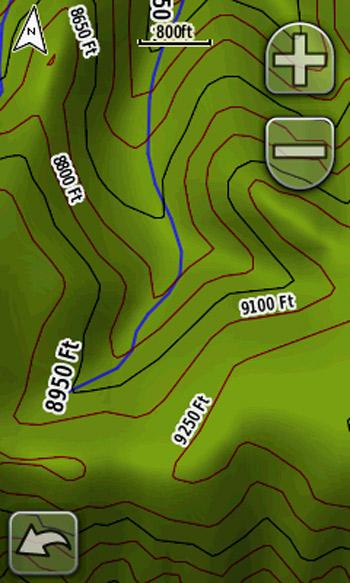
Topo Map Viewed on GPS: While this topo map, viewed off of a good GPS screen, is clear and easy to read, it's limited in how much detail you can see due to the small screen vs a larger printed topo map. Using both in tandem is hard to beat.
Practice Makes Perfect
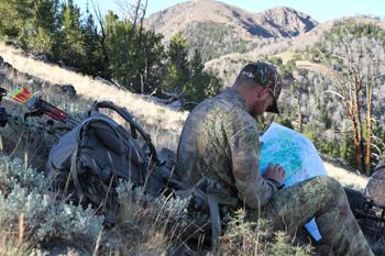
I'm not going to try any make anyone think that learning to read maps and understand GPS technology is fast and easy, because it isn't. It's not much different than learning to become accurate with your bow or rifle; it just takes time and practice.
If you have trouble reading maps accurately, then take the time to stop at a vantage point where you have a good view of the terrain around you and pull out the topo map. Compare how you see thing on the map with the actual terrain, and it will help you improve over time.
The same goes for learning how to use your GPS to its full potential. You aren't going to get much out of it if you only designate a few minutes right before you leave for a hunt to try and load some map software onto your GPS. Designate at least an evening or two prior to your hunt to learn how to load the items you want and then allow yourself time to test it out, so you know you have what you need and how to use it.
Wrapped with a Bow
To summarize, I use three different tools that give me different types of data: 1) a BLM or Forest Service map that shows broad scale; 2) a GPS loaded with third-party map software; and 3) a good 7.5-minute map that can show me detail for reading terrain accurately.
This system may seem excessive to some, but it makes a huge difference in the outcome of my hunts. There is nothing worse than getting up on a vantage point, seeing a large herd of elk a few miles away, and having no idea how to access them or if they are even on public land. Without a good map system, it can ultimately cost you your trophy bull. Take my advice and make sure you invest the time and money in having the mapping equipment and info you need to get the most out of your hunt.
Elk Hunter Magazine and appears courtesy of Elk Hunter Magazine. Elk Hunter Magazine is THE magazine for the hunter passionate about elk hunting, and is made up of the most experienced, well-respected elk hunters in the industry.
By Nate Simmons
Integrating today's mapping technology to better your hunt
©Copyright Elk Hunter Magazine
Two of the most overlooked and underrated pieces of equipment these days are maps and GPS devices. No doubt, there are far more exciting pieces of hunting equipment out there that are far more fun to use and play with. However, when it comes to aiding to the success of any hunt (public land especially), a good map/GPS combo is as important as your weapon or optics.
While having just a map or GPS alone is better than having neither, the combination of both is critical to get the most out of your hunt, especially when hunting new areas. I actually still pack both even when hunting familiar terrain, for two reasons: 1) It can be hard to find your way back to camp or the truck in the dark without a GPS, and 2) I like having a printed map to make notes on what I experience, so I can keep adding to my log and help notice patterns and subtle trends.
The reason I feel it's important to have both is that you can't get a good feel for the lay of the land (topography wise) by viewing a topo map on a GPS screen; there just isn't enough screen real estate to see much area in detail, and that's important to be able to see how drainages tie into one another and spot possible travel routes, glassing points, etc. And while a printed map has its strengths, it can't tell you precisely where you're standing and how to make it back to a particular location like a GPS can.
Another important aspect to consider is land ownership info. This can be displayed nicely on both printed maps and in GPS mapping software. There are some great custom map-making companies out there catering to hunters by printing maps with multiple data overlays on them, such as game management unit boundaries, BLM, state, Forest Service and private land boundaries on them. The great thing about these maps vs. a standard Forest Service or BLM map is that you have the ability to only print the area you want to see, whether it's your entire unit or units or a section of your hunt unit at whatever scale you prefer. Typically, a BLM or Forest Service map doesn't offer much detail in topography as they scale back to show large amounts of terrain. That makes it hard to see things like benches, subtle saddles, etc., with the scale of these maps in the range of 1:100,000 and greater. That translates to about one inch representing roughly 1.6 miles or more, where a good detailed topo map will be at a scale of 1:24,000 (referred to as 7.5-minute series), with one inch representing roughly .4 miles, allowing you to see far more detail in the topography. The problem with custom maps is that it can get expensive in a hurry.
My Mapping System
What's the solution? Well, there isn't a perfect one, but here is the system I've been using on my hunts, as it gives me all the data I could possibly need. For having access to data on land ownership status, I use two things: 1) a BLM or Forest Service map. This allows me to see large amounts of data at once and see the big picture on where the public lands lay and how to access most of them. I typically don't pack this one with me all the time, but just keep it in the truck or at camp in case I need it; and 2) a GPS, along with third-party software loaded onto it that shows all the land ownership status data, game management unit boundaries, and in some cases, the names of the private landowners. This is very powerful info, as it can do what no printed map can - show you where you are located in relation to a property line. This is a huge confidence-builder, as property lines are not always marked accurately, or at all.
HuntingGPSmaps Third-Party Software
The third party software I've been using is called "HuntingGPSmaps", made by Montana Mapping & GPS, LLC (available at the Long Range Hunting Store). This company has a good understanding of what hunters want and need, and how to make the product easy to use effectively. This product is sold several ways.
MontanaGPSmaps Software on Garmin GPS: Here you can clearly see on the GPS screen what the land ownership status is - and even the private landowner's name - by using the MontanaGPSmaps software. The best part is that the GPS will show you your exact location in relation to a property line.
Option 1 is to buy a mini SD card that can be inserted into compatible Garmin GPS units. You can see a list of compatible GPS models on their website, as well as a list of retailers.
Option 2 is to download the software from their website onto your home computer. You can then transfer it onto your GPS.
The map software is sold on a state-by-state basis and costs about $100 per state for the SD card and $130 per state for the downloadable versions. While both of these versions work the same way on your GPS, they do have their pros and cons. The mini SD card is easier to get going, as all you do is insert the card and go. The download is more time-consuming and takes a little time getting it transferred from your computer to the GPS, but the benefit is that you can view the map on your computer as well, which is nice for scouting and seeing a larger area than you can on a small GPS screen.
While this software is not inexpensive, it's still a value when compared to the cost and time of getting even small areas of a state printed on a custom map with the land-ownership layers, not to mention you can't pay a paper map to tell you exactly where you're standing in relation to a property line (priceless info).
USGS Quads
So this takes care of everything on the land ownership status front, but having the BLM or Forest map along with the GPS software still doesn't offer much for detailed topography. Even though the HuntingGPSmaps software offers great detail at a scale of 1:24,000, which is what I want, the problem is that when you are zoomed in, the GPS screen is too small to see much country at once.
Because of this, I still need another map. For this, I just need a basic map at a scale of 1:24,000 that has contour lines and shows where the timber is located, so I can see the lay of the land easily. There are several ways to track these maps down, but a USGS 7.5-minute quad is hard to beat for the price. They cost $8 per map and each map covers roughly 60 square miles on a 16"x22" sheet of paper. The drawbacks are that these don't offer shaded relief, which makes them a little tougher to read the contours, and you can't have the USGS center a map on a particular location (they are all fixed areas).
This can be a pain if your hunting area lies on the edge of two maps and you have to piece two maps together to see your area. You can either buy these online at www.usgs.gov, or track them down fairly easily by asking around at local sporting good stores.
National Geographic Topo Series
Another way to go is with the National Geographic Topo State Series software. It allows you to print your own maps at home at the scale you select and the exact area you select, but unless you have a giant plotter, you will have to tape papers together to see much at once. The other downside is the price; it's $50 per state, so it depends on how many places you hunt each year and how many maps you need in order to see if the price is worth it. These maps, like the USGS qu
BirdsEye Satellite Imagery
Seeing vegetated areas is key for seeking out potential bedding areas and travel routes, but I take it a step further by downloading a satellite image onto my Garmin GPS. I've been using Google Earth to "scout" from home and see what my hunting area looks like from the sky, but it's not always easy to remember it perfectly. So, having an area's satellite image on your GPS can be a very useful tool - especially when hunting elk - to help locate good-looking meadows, timber pockets, etc.
BirdsEye Satellite Imagery: This is a screen shot of the BirdsEye Satellite Imagery from a Garmin GPS; it's not hard to see the value in this, as spotting the best meadows is even easier than reading a topo map.
I was able to get this onto my GPS through Garmin's website for $30 (annual subscription with unlimited downloads). If you know all the areas you will hunt in the next few years, you can download everything you need in the one-year subscription.
The product is called BirdsEye Satellite Imagery and you can find it at garmin.com. Click on the "Maps" tab and it will ask you what GPS model you own (to make sure you have a model that is BirdsEye-compatible). The model I've been using is Garmin's Oregon 550t. This is one of their higher end units with all the frills in a 1.5"x2.5" high-res touch screen and 3.2-megapixel camera built in, preloaded U.S. topo maps, barometric altimeter, 3-axis electronic compass, and microSD card slot. There are less expensive models that will accept the third-party software by MontanaGPSmaps and also the BirdsEye Satellite Imagery, such as the Garmin Dakota 20 (touch-screen) and the eTrex 20 and 30 models (no touch screen). These will get the job done just fine, but they have smaller screens with a lower resolution and fewer frills.
Topo Map Viewed on GPS: While this topo map, viewed off of a good GPS screen, is clear and easy to read, it's limited in how much detail you can see due to the small screen vs a larger printed topo map. Using both in tandem is hard to beat.
Practice Makes Perfect
I'm not going to try any make anyone think that learning to read maps and understand GPS technology is fast and easy, because it isn't. It's not much different than learning to become accurate with your bow or rifle; it just takes time and practice.
If you have trouble reading maps accurately, then take the time to stop at a vantage point where you have a good view of the terrain around you and pull out the topo map. Compare how you see thing on the map with the actual terrain, and it will help you improve over time.
The same goes for learning how to use your GPS to its full potential. You aren't going to get much out of it if you only designate a few minutes right before you leave for a hunt to try and load some map software onto your GPS. Designate at least an evening or two prior to your hunt to learn how to load the items you want and then allow yourself time to test it out, so you know you have what you need and how to use it.
Wrapped with a Bow
To summarize, I use three different tools that give me different types of data: 1) a BLM or Forest Service map that shows broad scale; 2) a GPS loaded with third-party map software; and 3) a good 7.5-minute map that can show me detail for reading terrain accurately.
This system may seem excessive to some, but it makes a huge difference in the outcome of my hunts. There is nothing worse than getting up on a vantage point, seeing a large herd of elk a few miles away, and having no idea how to access them or if they are even on public land. Without a good map system, it can ultimately cost you your trophy bull. Take my advice and make sure you invest the time and money in having the mapping equipment and info you need to get the most out of your hunt.
Elk Hunter Magazine and appears courtesy of Elk Hunter Magazine. Elk Hunter Magazine is THE magazine for the hunter passionate about elk hunting, and is made up of the most experienced, well-respected elk hunters in the industry.

