You are using an out of date browser. It may not display this or other websites correctly.
You should upgrade or use an alternative browser.
You should upgrade or use an alternative browser.
Reading Topo maps
- Thread starter milboltnut
- Start date
milboltnut
Well-Known Member
Would you look at my topo maps and tell me where you would come in at ? I know the direction of the wind would dictate that but then seeing me coming is another, I'll have to decide about the wind when I get there.
extremesolo
Active Member
If you really want help being able to visualize what you are seeing on a topo map and using it to speed up your learning curve I highly recommend buying the book Mapping Trophy Bucks by Brad Herndon. I have a fairly extensive hunting book library and this is easily the best book I have as far as being able to read and apply the concepts. He does a great job of describing a what a particular terrain feature looks like in real life, how deer utilize that feature and then shows actual topo pictures diagraming the feature so you can pick them out on your own maps. I reference it often and it is a game changer especially if you are just going down the rabbit hole of online scouting. Once you get the idea it will save countless hours of scouting time in the field. You can narrow down a few likely spots to actually put boots on the ground instead of wandering around in worthless locations.
azarcher10x
Well-Known Member
- Joined
- Nov 12, 2012
- Messages
- 241
Try to find old tops if possible. Most maps printed since Clinton's roadless rule, leave out a lot of old logging roads, etc. Also, you need to remember, in the US, etc., the map datum on those are NAD27. To be accurate with a GPS, you'll need set your GPS to match. It's sad the topos on the GPS's nowadays won't show the roads either. You can pick them out on Sat maps sometimes.
I use a combination of topo and 21 century. Google earth, Gaia GPS, are awesome in evaluating an area. I dont western hunt, but do a lot of back country hiking in Montana and Wyoming. I can actually map out my hike and see what it looks like
ELKAHOLIC247
New Member
Get ONX HUNT. You can then toggle between satellite, hybrid and topo.
ONX has many useful tools such as tree species, water, etc.
ONX offers a free trial period.
ONX has many useful tools such as tree species, water, etc.
ONX offers a free trial period.
RUFFIAN R - NY
Well-Known Member
go get a spy plane or a drone !!!!!
azarcher10x
Well-Known Member
- Joined
- Nov 12, 2012
- Messages
- 241
BaseMap does everything OnX does for a lot less. I've used Gaia for years because they had all the USGS topos I've used since the sixties. Now i use both. I was able to transfer everything from Gaia to BaseMap.
milboltnut
Well-Known Member
Huntstand has satellie, hybrid and topoGet ONX HUNT. You can then toggle between satellite, hybrid and topo.
ONX has many useful tools such as tree species, water, etc.
ONX offers a free trial period.
Of course, direction with respect to sun, shade, vegetation, winds, cliffs to fall from/hinder movement, fields, creek/ponds/natural water collection sources, wet areas, abandoned /active roads, man made structures..........pretty much a encyclopedia for the reading.......the plot always thickens the more one studies it.Other than elevation, saddles, peaks, draws, directional indications of draws for funneling deer, is there anything else that would be helpful to navigate ?
milboltnut
Well-Known Member
well that narrows it down Pro2A !
milboltnut
Well-Known Member
Mapping Trophy Bucks by Brad Herndon has to be good for 90 bucks ! On ebayIf you really want help being able to visualize what you are seeing on a topo map and using it to speed up your learning curve I highly recommend buying the book Mapping Trophy Bucks by Brad Herndon. I have a fairly extensive hunting book library and this is easily the best book I have as far as being able to read and apply the concepts. He does a great job of describing a what a particular terrain feature looks like in real life, how deer utilize that feature and then shows actual topo pictures diagraming the feature so you can pick them out on your own maps. I reference it often and it is a game changer especially if you are just going down the rabbit hole of online scouting. Once you get the idea it will save countless hours of scouting time in the field. You can narrow down a few likely spots to actually put boots on the ground instead of wandering around in worthless locations.
milboltnut
Well-Known Member
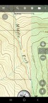
Is this an example of a bench where red exclamation marker is ?
