UTM?

Red Sparky

Well-Known Member
Joined
Sep 19, 2011
Messages
214
Location
Los Lunas, NM
How many of you use Universal Transverse Mercator instead of long/lat minutes and seconds? I just started using UTM with my new topo maps and find it easier once you get use to it. It seems like my gps has converted all my way points found using minutes and seconds when I changed the gps to UTM.
 
I see to do a significant amount of mapping for work. Ah the gold old days now they've stuck me indoors to sign purchase orders and run budgets. UTM can certainly be easier to visualize distances between features as everything is in yards. The one issue is when you are near a new something's don't always line up. California being such a long state has portion a of three zones which made things interesting. Any GPS unit or GIS program worth its salt should convert the display units to the coordinate system you choose. 20 years ago that was the voodoo portion of map making. Being able to coordinate layers in multiple units and datums. Now it's all plug and play.
 
Absolutely!
Ive been teaching orienteering for about 20 years. UTM is way easier to teach and understand!

Ques. How far is a minute? No matter what answer you give it will be confusing as a minute at the equator is longer than a minute at the poles.

With UTM the earth is flattened to a 1000 meter grid. I can teach 1000 meter grid to kids and the importance of correct declination.

Not so much with Lat/Lon
 
I see you are from this big long state as well. Ever run in to the issue of overlapping zones? I used to get fits trying to make maps that covered the whole state. I haven't done anything like that in over ten years though so I am sure the software is much better at correcting today than it was then. Dealing with Datums and coordinate systems manually in the old ArcView was a nightmare!
 
over lapping maps

yes, there are a number of programs you can print your maps as needed. When I bought maps at the store it seemed I always had to buy 4!!!
 
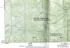
One trap that I have noticed down under is when using UTM grid reference numbers from the vertical grid lines the number lacks the right amount of zeros at the start to make the correct 7 figure number that you enter into a GPS. Like at the base of the map it will have a number at each vertical line .
Say for example 700 000 metres East . Now that is a six figure number but GPS with UTM likes 7 figure numbers.
So if you enter 6 figures , 700000 my GPS will append an extra zero to the end to make it a 7 figure reference , so making it 7 000 000 , the wrong number .
To get the right number into the GPS I have to append a zero in front of the number , like 0700 000 meters East .
However going from the GPS reference to the map is easy .
I am not sure if the same situation exists on US topo maps or if it's just my Garmin GPS that does it .
I guess what size numbers are present on the map depends on where the map starts from .
I will post a picture to illustrate what I am trying to explain .
 

Attachments

  • grid.jpg
    grid.jpg
    71.5 KB · Views: 151
Hmmm
Never noticed that! I will have to check out my Rino and see how it does.

Try this, look online at a 7.5 min topo map and pick a spot with the mouse. how does that compare to your garmin?
 
Maybe I am not doing this right but here is what I did with my Rino. My map on the Arizona/New Mexico border has a Grid Zone designation of 12S, 100,000-m Squares: XC. So under setup and units I have the Us National Grid as Position Format and NAD 83 as the Map Datum which is the same as the map.

So there is a grave marked on the map I want to go check out, sorry I am morbid and love the old west since I live here. I love old mines, ghost towns and graves and homesteads. So the location is 12S XC 82400/35000 in the Rino. I guess if I had to put 7 numbers in it would be 0682400/3735000. I would have to put the zero in front of the 6 as on the map it is 682400.

Now with 12S XC 82400/35000 I put that on Topo 2008 and can see I am really close to where the map says the grave should be. I can probably get closer with an actual tool to measure as I estimated the last 3 numbers for both positions. I plan on scouting here in the next couple of weeks so will tell you how close I am.
 
The situation on the topo map is the same in the US . I thought it would be.
The situation inside a GPS may vary as to how it handles a shortened grid reference number .
Some may shorten the number from the right which will make it the right number with less precision . However I would have thought that your second reference number of 35000 could not be right if you enter it as 3735000 instead , as you stated .
To reference 35000 meters I would enter 0035000 . Although the US National grid is based on the UTM system I would tend to use UTM setting in the GPS if you have taken a grid reference from a UTM grid based map and enter the same datum that is on the map . Then the GPS will convert it and navigate using WGS84 the datum in the satellites but read out you position data to suit the map datum .
National Grid is more like the Military grid system MGRS as far as I can tell , I could be wrong .
 
I am so confused right now. I went to MyTopo and ordered a map instead of buying four maps since I usually hunt where two or more topo maps come together. Here is what the legend on the bottom of the map says. In black it says Universal Transverse Mecator (UTM) projection zone 12. The line under that also in black says North American Datum of 1983 (NAD83). Under that in blue it says 1000 meter UTM / USNG / MGRS. The next line in blue says Grid Zone Designation: 12S . The final line in blue says 100,000-m Squares XC

Using the USNG with the 12S and XC put in I only have to enter the last five numbers. If I change the GPS to UTM UPS for that grave site it changes to 12 S 0682400 over 3735000. The MGRS and USNG have the same location designation. Either way I get to the same place it just depends on what information I have to put in.
 
That sounds right to me , quoting the XC when using USNG just takes the place of quoting the actual full numbers .
It's the same reference . Why map makers want to reinvent the wheel amazes me . My advice is use NAD83 datum UTM / UPS setting and the full reference 12 S 0682400 over 3735000 . that way it's the same system all over the World and you can navigate with that grid system anyplace on the planet.
The UPS stand for Universal Polar Sterographic which is a special grid for polar regions . The USNG and MGRS systems are supposed to be quicker and to reduce reference mistakes , like referencing the wrong grid square .
 
Warning! This thread is more than 10 years ago old.
It's likely that no further discussion is required, in which case we recommend starting a new thread. If however you feel your response is required you can still do so.
Top