Density Altitude adjustment question

djtjr

Well-Known Member
Joined
Oct 28, 2008
Messages
277
Location
New York, NY
Guys is there a mathematical way to rapidly compute altitude or really pressure differentials for a given drop chart as you get away form sea level? I live at sea level but a lot of my hunting is done at Higher altitudes and lower pressures than where i am on the east coast? To simplify my query, is there a multiplier that you can use perhaps equivalent to suing a cosine calculation for shooting at an angle? I know i can do it relatively quickly in shooter or bullet flight but i am wondering if there is a way to take technology out of the equation (except for a kestrel to get an accurate pressure measurement) since on a 10 day sheep hunt who knows what will and wont be working when the time comes to make your shot. In the past i have just made multiple drop charts but it would be nice to have one chart that with some basic math you can adjust for given pressure variables.
 
Yup i use that too but looking to see if there was a simple way to do it in the field with minimal technological help. Is there a rule of thumb that works per 1000 feet etc? It may not be what you want to use for a 1000yd shot but can keep you in the kill zone at 6-700 etc...
 
Here is my "cheat sheet" taped to my Leica, for my 6.5/284 load. The basic dope sheet (taped to the scope tube on the rifle) is based on the altitude and temp expected on the hunt, then I ran additional calcs for higher and lower alt, higher and lower temps, and recorded the difference from the base dope on the rangefinder body. At 1000 yards, a 1000ft alt change is worth a half minute of correction, 20 degrees is also worth a half moa. At 800 yards, it takes 2000ft or 40 deg to require a half moa correction, and so forth. While not as precise as my new G7BR2, it worked reasonably well for the price, which was free...
 

Attachments

  • Rangefinder Dope Cards 003.JPG
    Rangefinder Dope Cards 003.JPG
    78.4 KB · Views: 115
If you are going to be carrying one range card what would be the issue with carrying five or six? I would say I'm a firm believer in simplicity. Simple is better. I will print multiple range cards corresponding to each 1000 ft of density altitude (DA). I will change cards corresponding to current environmental conditions as I hunt throughout the day. I don't see why range cards couldn't be created with multiple columns corresponding to DA change. My preference would be to keep the card clean to ensure the wrong column is not read. There is enough going on when the decision is made to potentially take a shot. I don't want multi-column cards if not necessary. If I'm carrying one card I find it just as easy to carry multiple. Just my $.02.
 
I use JBM and have individual range cards for the areas I hunt. I use 4000 ft for my coues wt hunts and 8000 ft for my elk hunts.

Here are the true pressure/altitude values:( 
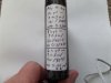
I realize that real time values and an ap would be better) This has worked quite well for my hunting needs.

Barometric pressure adjustments
500 29.27
1000 28.78
1500 28.29
2000 27.80
2500 27.32
2550 27.07
3000 26.82
3500 26.33
4000 25.84
4500 25.37
5000 24.90
5500 24.43
6500 23.57
7500 22.71
8000 22.23
9000 21.27
9500 20.79
10,000 20.31
 
For several years before I acquired my G7 BR2, I was quite successful using clicks to correct for temperature and altitude changes. I had either a drop chart or more frequently a yardage turret for each of my hunting areas that was +/- 2000 ft elevation that used a temperature which was the seasonal average, example: Alberta-2000 ft/35F. My click correction for my particular rifle and .3MOA/click scope was:

Under700 yards:
-one click up for each 1500ft elevation increase, opposite for decrease.
-one click up for each 20F decrease in temperature, opposite for increase.
For over 700 yards, under 1000, my max), my corrections above were two clicks to correct.

A ballistic calculator was used to initially determine these adjustments. This worked for well over a dozen deer and antelope between 500 and 1000 yards. I actually had conditions where temperature and elevation cancelled each other out and I held on my base elevation and hit dead on. I make myself aware of the temperature and elevation and the corrections "before" I encountered my game. When game was encountered I just worried about, range, angle, and wind.
 
That true pressure chart is pretty accurate. I was testing a load yesterday at an altitude of 5858, and the pressure was 24.41, according to my BR2.
 
A Kestrol set to read Station PSI and a Shooter app set up the same way. How could it be any simpler??? No worrys about altitude!!!
 
What AZshooter gave you was pressure altitude...your half way there.
Density altitude= Pressure alt +[120x(oat-isa temp)]....well you asked for it. Had to check my notes from flight school years ago. Then depending on your cartridge and range, you can subtract or come down a click for every 1500-1700 ft or so.
 
I went with the BR2 rangefinder because it is that one step easier than the kestrel and shooter app. I don't carry range cards, so no adding or subtracting clicks for altitude or temp, sold my ACI so no more incline calculations. Too often I had game, varmints specifically, disappear before I got all my calculations made. I can get a shot off a lot faster now.
 
Warning! This thread is more than 10 years ago old.
It's likely that no further discussion is required, in which case we recommend starting a new thread. If however you feel your response is required you can still do so.
Top