Somewhere in most GPS setups there will be a function to either turn WAAS on or off on the unit. Anyway, here is the explanation to get better accuracy out of almost any GPS.
Wide Area Augmentation System
From Wikipedia, the free encyclopedia
Jump to:
navigation,
search
"WAAS" redirects here. For other uses of the acronym "WAAS", see
WAAS (disambiguation).


FAA WAAS logo
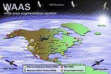
WAAS system overview
The
Wide Area Augmentation System (
WAAS) is an
air navigation aid developed by the
Federal Aviation Administration to augment the
Global Positioning System (GPS), with the goal of improving its accuracy, integrity, and availability. Essentially, WAAS is intended to enable aircraft to rely on GPS for all phases of flight, including
precision approaches to any airport within its coverage area.
[1]
WAAS uses a network of ground-based reference stations, in
North America and
Hawaii, to measure small variations in the GPS satellites' signals in the
western hemisphere. Measurements from the reference stations are routed to master stations, which queue the received Deviation Correction (DC) and send the correction messages to geostationary WAAS satellites in a timely manner (every 5 seconds or better). Those satellites broadcast the correction messages back to Earth, where WAAS-enabled GPS receivers use the corrections while computing their positions to improve accuracy.
The
International Civil Aviation Organization (ICAO) calls this type of system a
satellite-based augmentation system (SBAS). Europe and Asia are developing their own SBASs, the Indian
GPS Aided Geo Augmented Navigation (GAGAN), the
European Geostationary Navigation Overlay Service (EGNOS) and the Japanese
Multi-functional Satellite Augmentation System (MSAS), respectively. Commercial systems include
StarFire and
OmniSTAR.

